Introduction to Great Knelle Wood
- an Ancient Woodland in the High Weald
KNELLE
WOOD
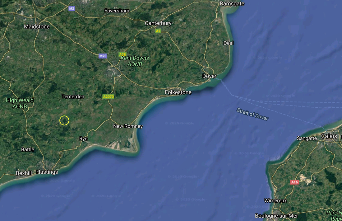
Great Knelle Wood is ancient woodland on the eastern edge of the High Weald of south east England. It is large enough to be seen in satellite images, such as that of Google Earth. That image was as viewed from about 125 km altitude : the wood was the dark green area in the middle of the yellow circle.
The origins of Great Knelle Wood are lost in time but its official designation as an 'Ancient Woodland' means that it has been continually wooded since at least 1600 AD. Since little woodland planting took place before that date, it is most likely to have grown up naturally. It may even link back to the original wildwood that covered the UK around 10,000 years ago, after the last Ice Age.
Cartography
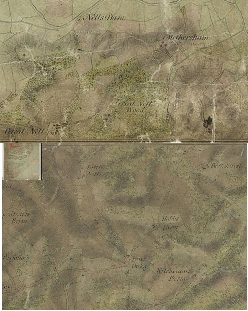
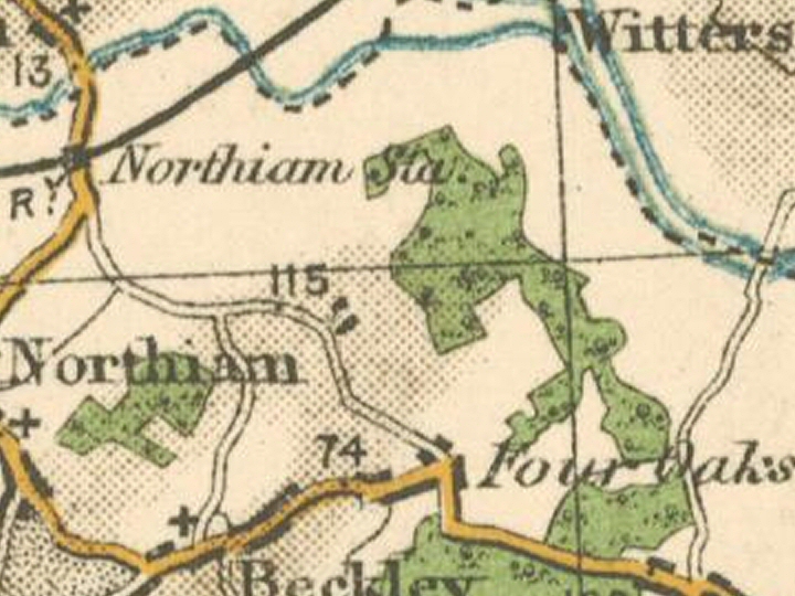
What we do know is that in the late 18th century the wood was recorded as Great Nell Wood. The image here is a composite of parts of two maps prepared by the Board of Ordnance during the Napoleonic Wars, now held by the British Library and available on line [opens a new tab]. The upper part is from 'Cranbrook' dated 1797 and the lower part is 'Rye' dated 1799. The central west buildings are recorded as Great Nell where Great Knelle Farm is today. Overlaying modern cartography [hover your mouse over the map] shows that little has changed although the early map clearly was not as accurate as that made with today's technology [the overlay was centred on Great Knelle Farmhouse]. You can click on the image to the left to bring up a larger version of the map but it may take a while to load.
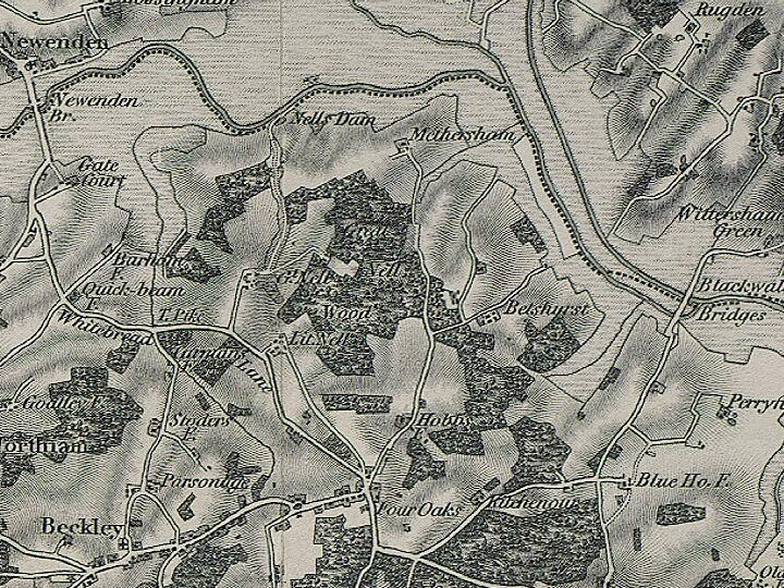
By the mid 19th century the maps are recording the spelling in the old [and modern] way so the map makers presumably just wrote what they heard rather than recorded the spelling of the day. Fundamentally though, the shape of the wood remains unchanged through all of the subsequent issues of the Ordnance Survey maps to that which we see today.
[boundary map]
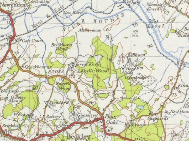
Each of the above thumbnails is a link to a larger map : just use your browser's 'back' arrow to return here.
Geography
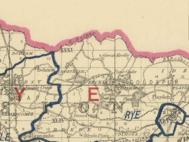
The wood is on the northern slope of a small ridge which gently slopes down to the banks of the River Rother as it wanders through the levels towards Rye. It is bounded on the north by Methersham Farm, on the east by the Bellhurst Farms and on the west by Great Knelle Farm. To the south is the hamlet of Four Oaks, an outlying part of the village of Beckley. The wood is towards the northern end of the parish of Beckley :
The river we see today is nothing like it would have been 1000 years ago. Until the 13th century the area around Rye was a vast natural harbour [opens a new tab] rather like Chichester, say, with trading boats coming up to Tenterden and Newenden/Northiam on the west side. Indeed, there was a flourishing boat building industry at Tenterden. The sea level was probably higher than it is today so it could well be that Methersham Farm was on the harbourside. At this time the river flowed out to sea through Romney which was the major channel port of the era.
Everything changed in 1287 when a violent storm created havoc throughout the English Channel and the North Sea [it created the Zuider Zee for instance]. The storm threw up a bank across the river's entrance causing it to find a new route, the one we see today which flows past Rye. From then on the harbour slowly silted up to form the levels of today.
Geology
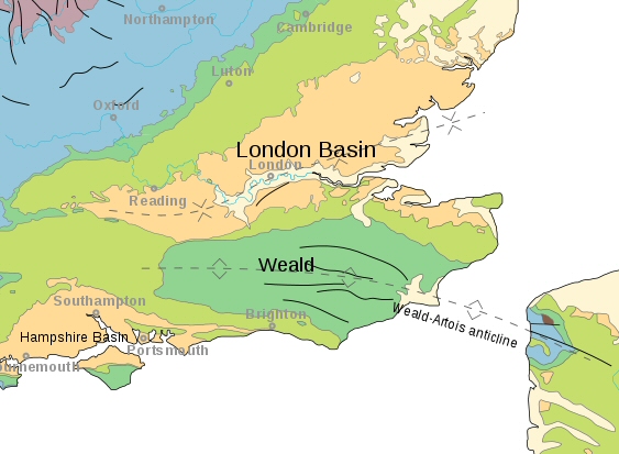
Geologically, the Weald is the remains of a rock dome [an anticline] thrown up in that period of time when the Alps, the Pyrenees and other Mediterranean mountains were formed. The dome, known as the Weald-Artois anticline, stretched across what is now the English Channel into France. As it was eroded over the millennia the underlying rocks were exposed by wind, rain, ice and snow. [Note, however, that the icecap of the last ice age did not reach this far south.] As before, you can click on the image to bring up a larger version of the map and use your browser's 'back' arrow to return here.
The High Weald is, ironically, on the exposed sandstones at the lowest levels of the original dome. This can be clearly seen on the north/south geological section.
Great Knelle Wood is on the fringes of the High Weald. The small ridge on which it lies is formed of Tunbridge Wells Sand so the southern part of the wood is on sandstone while the lower-lying northern part is on the underlying Wadhurst Clay.
Climate
The wood is in the warm, dry southeast of the UK :
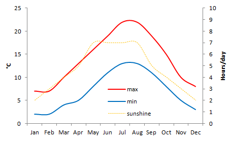
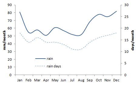
The average maximum temperatures peaks at 22 °C in July and August and the average minimum stays 2 °C above freezing in January and February. On average there are at least two hours of sunshine a day with a peak of 7 hours a day during the summer months. The average rainfall, which totals 770 mm per annum, is remarkably uniform throughout the year. Even in winter there are only 18 rain days a month and in summer there are still 11 days on average. The average rainfall itself is in a narrow band of 50 to 80 mm per month.
Of course, there are 'lies, damn lies and statistics'. At this stage we don't have the data extremes which will, I am sure, tell a different story and the averages don't reveal the climate change trends which could well have an impact on the wood in the next few decades and certainly centuries.
To see how all that fits into the national climate picture, the UK Met Office has climate maps over three 30 year averaging periods [1961-1990, 1971-2000 and 1981-2010] for most parameters in the UK Climate part of its domain [opens in a new tab on your browser, just close it to return here].
History
The word Weald derives from Saxon for forest and is therefore related to the modern German 'Wald'. In Anglo-Saxon days it was known as Andredes Weald but you would be wrong to think that it belonged to someone called Andred, it is derived from the Roman name of Pevensey : Anderitum. In 1066 William of Normandy landed there to claim his kingdom.
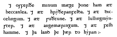 In fact, the recorded history dates from before William's arrival. When Alfred the Great died he bequeathed what we now know as Beckley to his cousin :
And to Osferth, my cousin, the Manor at Beccanlea, and at Rytherfield, and at Dicceling, and at Suthtune, and at Lullingminster, and at Angmering, and at Feltham and the Lands that thereto belong.
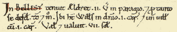
Bellhurst, on the eastern boundary of Great Knelle Wood, is mentioned in William's Doomsday Book. The lord [in Edward's reign] was Aldred who held 2 virgates in parage, and at so much it was assessed then as now. There [King] William has in demesne 1 plough and 1 villan with 1 plough. It is and was worth 7s [7 shillings].
The only other possible mention of the area in Doomsday is a place called 'Merclesham' which some have identified as Methersham on the northern boundary of the wood. The problem is that the River Rother is the boundary between Kent and Sussex yet Merclesham is listed in Doomsday as being in Kent.
At the time of the Norman invasion, Sussex - the land of the South Saxons - was divided into four 'rapes' : Arundel, Lewes, Pevensey and Hastings. The rapes were subdivided into 'hundreds', each having enough land to sustain approximately one hundred households. Great Knelle Wood was in the Goldspur hundred of Hastings rape, a hundred which stretched from Newenden down beyond Rye. For taxation purposes Goldspur was divided into four tithings, the most north-easterly of which was Knelle, more or less the equivalent of modern Beckley parish.
The Manors of both Knelle and Methersham were granted to William's lords at some stage or other. There is a good history of the Manor of Knelle [again opens a new tab] available on the internet. There is no such equivalent for Methersham although a search does show that it needs further investigation, if only because it is shown to be a modern vineyard!
There is ironstone in the underlying strata, something which the Romans were aware of, as evidenced by the remains of their bloomeries within the High Weald. By the 16th century, the area around Great Knelle Wood was part of the Wealden iron industry. We know for sure that an iron furnace with waterwheel driven bellows was built just south of Beckley in 1578. That part of the district is still called Beckley Furnace today. In the mid 17th century ships' cannons were being produced there, probably for the local shipbuilding industry. Ultimately, though, the industry collapsed as coke based iron making was introduced in the north of England. Production at Beckley Furnace had ceased by 1770.
Times were hard around Beckley in the 19th century. At the time the British colonies were desperate for labourers and came up with schemes to entice people from the homeland to emigrate. It is reported that, in the 1830's alone, 165 residents of Beckley took up an offer from New South Wales and emigrated to the east coast of Australia. Among them were Thomas and Maria Ann Smith and their family. It was Mrs Smith who subsequently discovered a natural cross apple seedling out there : the Granny Smith.