Peasmarsh in History
Peasmarsh, perhaps "the place of the marsh pea", is on the edge of the Sussex Weald. The word 'Weald' derives from Saxon for forest and is therefore related to the modern German 'Wald'. In Anglo-Saxon days it was known as Andredes Weald but you would be wrong to think that it belonged to someone called Andred, it is derived from the Roman name of Pevensey : Anderitum. In 1066 William of Normandy is said to have landed there to claim his kingdom.
Peasmarsh is not mentioned in William's Domesday book although both the adjoining parishes to the east - Iden and Playden - are, as is Heighton which is said to be almost on the outskirts of modern day Peasmarsh just 2 km from The Old Rectory. In total the book names five places in the hundred of Goldspur which rather begs the question of what a hundred was [and before being too smart, please remember that a Roman century actually consisted of about 80 men, not 100] : the way that the extent of a hundred was determined was that each hundred had enough land to sustain approximately one hundred households. However, the households counted in 1086 for the Domesday survey of Goldspur hundred was only 54 so not being mentioned does not mean that Peasmarsh didn't exist at that time : the survey was accurate but not necessarily complete.
Two centuries later an exercise not dissimilar to the Domesday survey was ordered by Pope Nicholas IV in order for him to raise revenues from the churches of the Christian world : the 'Taxatio'. The survey for England and Wales seems to be the only surviving part of the work. It was undertaken in 1291 and 92 during the reign of Edward I. What is interesting is that the dominant local parish was Peasmarsh [variously 'Pesemersse' and Pesemersshe] which is called 'Pesemersse (annexed to the Prebend of Peasmarsh of Hastings Collegiate Church)' in the survey and is under royal patronage. The parishes of Beckley, Northiam, Iden and Playden were all subsidiary to Peasmarsh at that time in as much as they all paid 'pensions' to Peasmarsh.
There is ironstone in the underlying strata of the High Weald, something which the Romans were aware of, as evidenced by the remains of their bloomeries within the High Weald. By the 16th century, the area was part of the Wealden iron industry. We know for sure that an iron furnace with waterwheel driven bellows was built just 5 km west of Peasmarsh in 1578. That part of the district is still called Beckley Furnace today. In the mid 17th century ships' cannons were being produced there, probably for the local shipbuilding industry. Ultimately though, the Wealden iron making industry collapsed as coke based iron making was introduced in the north of England. Production at Beckley Furnace had ceased by 1770.
Times were hard around Peasmarsh in the 19th century. At the time, the British colonies were desperate for labourers and came up with schemes to entice people from the homeland to emigrate. The National Archives at Kew have a series of documents dated May 1838 to the Poor Law Commission from William Morris,the 'Overseer' of Peasmarsh, which are emigration papers. The parish wants to borrow £80 to help six families emigrate, a total of 33 souls on this one occasion alone. It is the only known emigration record for Peasmarsh but records show that 165 residents of neighbouring Beckley took up offers from New South Wales in the 1830's and emigrated to the east coast of Australia. Among them were Thomas and Maria Ann Smith and their family. Maria, nee Sherwood, was born in Peasmarsh in 1799, marrying Thomas in 1819. This is the Mrs Smith who subsequently discovered a natural cross apple seedling out there : the Granny Smith.
We now [2015] have two Ordnance Survey Maps from the end of that century that cover the east end of Peasmarsh. They are Second Edition 1:2500 series maps published in 1898 from original surveys of 1872, revised in 1897. The western one is Sussex [East] XLV.1 and the eastern one XLV.2. Small parts of each have been stitched together below with a thin red line to indicate the stitch line :
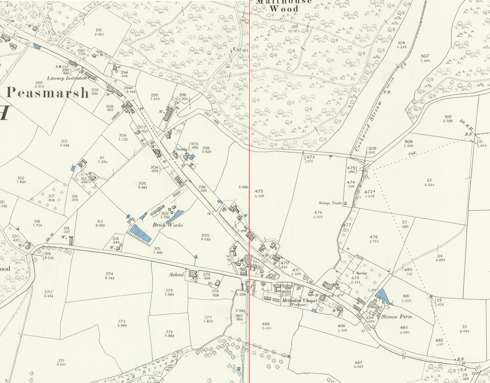
If you hover over the map you will see part of the modern equivalent overlayed. There is not a perfect match so the overlay is most accurate around the school on the southern part of the map. Our building is clearly visible next to the school. What you cannot quite see is that the stream which runs down through the wood called Van's Gill and along the south and east of the glebe land is called Corkwood Stream in the late 19th century and not Woodside Stream as we know it today.
Of note are the brick works [which makes sense when you see the clay beneath the top soil], the smithy and the 'Literary Institution'. The Cock Inn, although not marked, just shows with its pull-in and pull-out entrance at the top left of the map. Although the Horse and Cart is shown at the junction of School Lane and the main road it is not marked as an inn. Also of note but well off the parts of the map shown here, Vansghyll House up by Peasmarsh Place and the church is shown as The Vicarage. Perhaps what became The [Old] Rectory was being used as the Headmaster's / Headmistress' house at the end of the 18th century?
Thanks to Robin Thompson, a local historian and village archivist, and the East Sussex Record Office we now [2016] know a lot more about Peasmarsh and our building in the 18th and 19th centuries. The first treasure is a map from a survey made for Robert Mascall, possibly the then owner of Peasmarsh Place, in 1716. This is a part of the map :
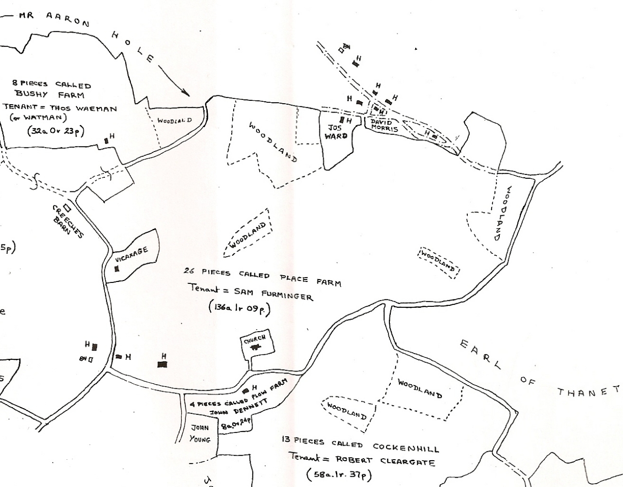
Part of ESRO ACC 4846 © David Martin
The part of the map shown covers a much greater area than the late 19th century one above. It is remarkably accurate when checked against a modern map produced with the latest survey techniques. At that time The Vicarage is clearly up the hill from the village to the west of the church [where Vansghyll House is today] and what eventually became The Rectory and surrounding land is shown to belong to one Jos(ia? or eph?) Ward. He is not a tenant of Robert Mascall but perhaps he is a tenant of the vicar / rector as the plot seems to conform with what is later confirmed to be glebe land [or, as you will see below, 'vicarage land']? He is discussed in more detail on the page about past inhabitants of The Old Rectory
The second treasure is the 1840 tithe map [hovering over the map will give a magnifying glass effect] :
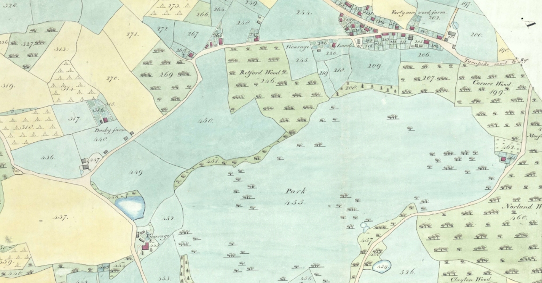
Part of ESRO TDE 12
This part of the map covers an area greater than the late 19th century one but less than the part of the 1716 one. The Vicarage is still on the same plot as in 1716 but is shown to be a much larger structure and the plot has been divided into two parts : plots 445 and 452. It is reported that it was built in the late 1830's which is supported by a set of plans held by the RIBA in London. They show that the Vicarage, now Vansghyll House, was designed by William John Donthorn, one of the founders of the RIBA. His client was the Reverend Dr Buckland. Josiah Rowles Buckland, a Fellow of Sydney Sussex College [Cambridge] was appointed as Vicar of Peasmarsh in 1833 following the death of John Lettice which makes sense.
Down the hill, the east end of the village has started to take on the structure seen in the late 19th century map. There is an area of land which is referred to as 'vicarage land' although it is unclear what the extent truly is. In the associated tithe list, plots 218 to 221 are all shown to be owned and occupied by the Reverend Thomas Buckland. The problem is that in the 1841 census, just one year after the tithe was recorded, the vicar is the Reverend Josiah Buckland so is 'Thomas' a mistake?
The first three plots are described as 'pasture land'. It is interesting that what was later termed the glebe land was divided into two parts in 1840, more or less along the line of the modern boundary between the land of The Old Rectory and the school land. Plot 218 was called Stream Field in 1840, 219 was - perhaps unsurprisingly - Long Field and 220 - equally so - was House Field. Our building is in a separate plot, 221, which looks to encompass where the school was to be built just two years later. It is called Street Land and described as a cottage and garden.